| Above: Icicles hang from a plant as a farmer uses water in an effort to keep it from being damaged by freezing temperatures on December 15,2010, in Homestead, Florida. Image credit: Joe Raedle/Getty Images. |
The circulations that drive day-to-day weather dictate when a given spot will experience the clear skies and calm winds that favor frost. According to the authors of the new paper, Courtenay Strong (University of Utah) and Gregory McCabe (U.S. Geological Survey), “recent efforts to relate a century of observed changes in U.S. frost timing to various atmospheric circulations yielded only modest correlations, leaving the relative importance of circulation and warming unclear.”
The new study uses a “clustering” algorithm to divide the contiguous U.S. into four regions—three latitudinal belts east of the Rockies (north, central, and south), plus a western region. It identified circulation features that account for one-quarter to one-half of frost timing during spring and autumn. “These circulations appear responsive to historical warming, and they consistently account for more frost timing variability than hemispheric or regional temperature indices,” the authors wrote.
 |
| Figure 1. Change in annual number of days in the average frost-free period for the period 1991-2012 as compared to 1901-1960. Image credit: Climate Central, data from 2014 U.S. National Climate Assessment. |
Thus far, most of the lengthening in the frost-free season is because of the last frost of spring arriving earlier, rather than the first frost of autumn showing up later. Autumn frost timing saw a significant change in just two of the four study regions (north and west). But all four regions now see their last spring frost occurring about 5 to 10 days sooner than it did a century ago. This lines up well with the observed trends in Northern Hemisphere snowfall. Snow cover during spring is declining markedly (e.g., in May), whereas that’s not the case in autumn (e.g., in November, when hemispheric snow cover has actually increased since the 1980s).
 |
| Figure 2. Projected increases in frost-free season length for the last three decades of this century (2070-2099 as compared to 1971-2000), assuming that heat-trapping gas emissions continue to grow (IPCC A2 scenario). Increases in the frost-free season correspond to similar increases in the growing season. White areas are projected to experience no freezes for 2070-2099, and gray areas are projected to experience more than 10 frost-free years during the same period. Image credit: NOAA NCDC/CICS-NC, via U.S. National Assessment). |
Circulation trends in a warming world
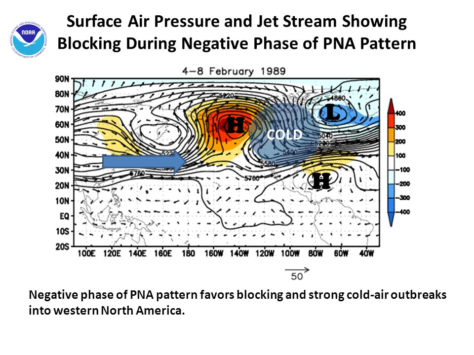
One would expect that a planet being warmed by human-produced greenhouse gases would tend to see longer frost-free seasons. That part isn’t complicated, and the new paper doesn't dispute it, but this research (and other recent work) is also trying to pry apart the role of circulation in determining where and when the planet warms up the most. Previous studies on frost timing have found some correlation in the western US to the Pacific-North American (PNA) pattern, whose positive mode (which has been prevalent in several recent winters) favors warmth in the West and cold in the East. Other work has found links to the Atlantic Multidecadal Oscillation. pattern in Feb. 1989 cold wave") |
| Figure 3. A strongly positive PNA pattern, featuring upper-level high pressure in the Gulf of Alaska and low pressure in eastern Canada, helped produce the historic cold blast that affected much of North America in the first week of February 1989. Image credit: NOAA |
So how much could global warming be stimulating these circulation changes? Rising global temperatures aren't distributed uniformly, and it appears that the circulation trends identified by Strong and McCabe are giving the contiguous U.S. more than its "share" of frost reduction, with a good bit of regional interaction between temperature and circulation. “It is fair to conclude that the circulation changes are an amplifier of temperature changes on a regional basis, especially during spring,” lead author Strong told me in an email. However, “on a global or hemispheric scale, there is [only] a certain amount of energy to distribute around the planet as temperature. Circulation-driven high temperatures in one place are usually accompanied by circulation-driven low temperatures in another.
“In terms of what drives these circulation patterns other than large-scale warming, these are relatively understudied transition-season (fall and spring) patterns, so we know relatively little about their origins,” Strong added. The PNA’s behavior is linked in part to El Niño and La Niña, but the atmospheric impact of those two phenomena tends to be biggest during the Northern Hemisphere winter rather than during fall and spring.
Research is increasingly turning toward the Madden-Julian Oscillation, which is best known for its organized areas of showers and thunderstorms that drift east through the global tropics every few weeks. An active MJO phase in the Indian Ocean may help stimulate a negative phase of the PNA, according to a study by South Korean scientists Kyong-Hwan Seo and Hyun-Ju Lee published this spring in the Journal of the Atmospheric Sciences.
Fear of false springs
Strong and McCabe point out that there are other key ways to measure the impact of spring and fall temperature trends on agriculture. Even in the midst of an overall warmer climate, as measured by heating degree days, circulation changes could still produce frosts or freezes late enough to damage crops.
 |
| Figure 4. Ben Clark walks among peach trees in full bloom at Clarkdale Orchards in Deerfield, Mass., on April 27, 2017. A year after late frosts and freezes led to a disastrous peach crop in the northeastern U.S., growers and agricultural officials were anticipating a healthy rebound for 2017. Image credit: Paul Franz/Greenfield Recorder via AP. |
Over large parts of the U.S., especially near coastlines, overall warming should help cut the risk of false springs, according to Allstadt and colleagues. In the nation’s midsection, though, it’s a different story. False springs could become more likely from the central High Plains to the Ohio Valley: here, the oceans’ moderating influence is more distant, and cold intrusions could still arrive well after the increasingly earlier leaf-out and first bloom.

Bob Henson
WU meteorologist Bob Henson,
co-editor of Category 6, is the author of "Meteorology Today" and "The
Thinking Person's Guide to Climate Change." Before joining WU, he was a
longtime writer and editor at the University Corporation for Atmospheric
Research in Boulder, CO. Twitter: @bhensonweather.
Contact:
Bob Henson
No comments:
Post a Comment